D1.1 Technology survey: Prospective and challenges - Revised version (2018)
5 Participatory / citizen science for water management
5.3 Participatory Sensing
For data collection in particular, more recently people turned their attention towards what is called Participatory Sensing [Campbell, 2006]. Unlike the traditional questionnaire-based collection processes, participatory sensing relies on electronic means widely available for collecting the data with the help of ordinary people. As mobile phones have evolved from devices that are just used for voice and text communication, to advanced platforms that are able to capture and transmit a range of data types (image, audio, and location), the adoption of these increasingly capable devices by society has enabled a potentially pervasive sensing paradigm - participatory sensing. A coordinated participatory sensing system engages individuals carrying mobile phones to explore phenomena of interest using in situ data collection [Paulos, 2008]. By enabling people to investigate previously difficult to observe processes with devices they use every day, participatory sensing brings the ideals of traditional community based data collection and citizen science to an online and mobile environment, while offering automation, scalability, and real-time processing and feedback [Cooper, 2007]. In particular, in participatory sensing, individuals explicitly select the sensing modalities (they are in control of their privacy-related data) to use and what data to contribute to larger data collection efforts.
For participatory sensing, usage models can range from public contribution, in which individuals collect data in response to inquiries defined by others, to personal use and reflection, in which individuals log information about themselves and use the results for personal analysis and behaviour change. A common workflow, combining elements common to both these extremes [Estrin, 2010] is presented in Fig. 29.
Figure 29. Common architectural components for participatory-sensing applications, including mobile-device data capture, personal data stream storage, and leveraged data processing.
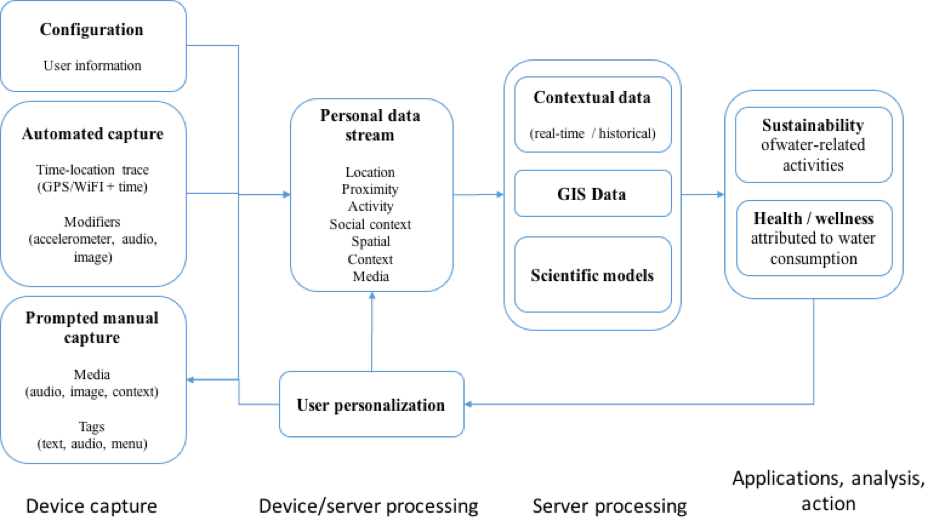
Mobile phones are extremely useful for ubiquitous data capture of everything from image, audio, video, to location data. They are equipped with broadband communication, so data can be sent for further processing to powerful external servers, and are capable to collect valuable contextual information. Because of the sheer ubiquity of mobile phones and associated communication infrastructure, it is possible to include people of all backgrounds nearly everywhere in the world.
The data collected with a mobile device can be further processed through a series of external and cross-user data sources, models, and algorithms, leading to the inferring of complex phenomena about individuals and groups. As many applications use also some sort of comparison of current measures to past trends, in the architecture we also have robust and long-term storage and management of this data.
An example of a participatory sensing project in presented in [Reddy, 2010]. There, authors demonstrate the creation of participatory sensing campaigns using smartphones, along with web services for data storage (Flickr and sensor database), analysis (Python application server), and visualization (Google Maps and Charts). One campaign, called “What's Bloomin”, deals with water conservation, by asking subjects to take geo-tagged photos of “blooming” flora. Having this inventory enables facilities to identify, using the plants, the water saturation within the soil, and draw conclusions as to when to replace high water usage plants with ones that are drought tolerant.
Other environmental / water-related applications include measuring pollution levels in a city, water levels in creeks, and/or monitoring wildlife habitats. Such applications enable the mapping of various large-scale environmental phenomena by involving the common person. An example prototype deployment is CreekWatch, developed by IBM Almaden Research Center [Sunyoung, 2011]. It monitors water levels and quality in creeks by aggregating reports from individuals, such as pictures taken at various locations along the creek or text messages about the amount of trash. Such information can be used by water control boards to track pollution levels in water resources.
There are also several downsides to participatory sensing. Finding a fit between diverse users and participatory sensing projects mirrors traditional selection for volunteer work based on interest and skill. But because participatory sensing is organized virtually / electronically, identifying best-suited particular participants (individuals who collect, analyse, and share their data) for campaigns (targeted data collection efforts) can be, thus far, only partially automated. Identification techniques for participants generally rely not only on participants' reputations as data collectors based contribution habits, but can on participants' availability in the area of interest [Lu, 2010]. Specific attention has to be paid to the fact that humans have self-will, exhibit varied data collection performance, and have mobility traits that are opportunistic in nature [Paxton, 2009].