D1.1 Technology survey: Prospective and challenges - Revised version (2018)
4 ICT based systems for monitoring, control and decision support
4.11 Decision Support Systems
Decision-support systems for water community-driven efforts
The current stresses on the waterscape have energized the creation of top-down and bottom-up interjurisdictional alliances that aim to collectively improve the status of watersheds and the search for sustainable solutions. By nature, effective watershed management requires information-rich communication among federal, state, and local governments, private industry, citizens, and academia [Muste, 2014]. Effective watershed planning, regulation and management also require timely conveyance of information to agency staff, decision makers, and the public. Customized Decision Support Systems (DSS) are required for this purpose to efficiently provide a wide access of workflows for querying, visualizing, and compare decision options. The data and information include real-time sensor data streams, inferences from the data, multi-domain modelling results, analyses results, user-defined inputs, and tools for evaluation and aggregation of unstructured data. A DSS can use the same information for strategic or emergency planning if the access to the data, simulations, and workflow operation are completed promptly, and ideally, in real-time. This type of customized DSS for water resources can uniquely meet the demand being put on governmental and local agencies to provide sound, cost-effective, and timely solutions by aligning existing resources in a way that allows to efficiently build on past efforts, leverage costs and resources, and continuously integrate products from new studies with minimum effort and resource investments. The platforms are actually acting as “enabling technologies” for benefiting effective integrated watershed management and ensure the decision-making sustainability.
Sound and efficient management decisions for timely mitigating accidental pollutant releases in rivers require a plethora of prerequisites, tools, and organization of the data and information in a manner that allow elaboration of the decisions in real time. Among the basic prerequisites for making sound decisions are: good knowledge of the pollution sources and their types, maximum allowed local concentrations for pollutant at each river location, maximum allowed concentration for safeguarding downstream water users and ecosystems, and the estimation of the pollutant mass and travel time in the river system for various accidental spillway scenarios. Pollutant mitigation strategies can take various forms: absorbents barriers, chemical neutralization, increasing the pollutant dilution by releasing water from the upstream reservoirs, etc. Establishing the most adequate strategy in each case of accidental pollution should be done in advance based on mathematical modelling. Since the accidental pollution is inherently unexpected, the sensors deployed in the river should be ideally equipped with real-time and unassisted transmission to promptly alert on any change in pollutant concentration and their relationship with threshold levels. This input information should be quickly passed to simulation models to enable quick decisions and formulation the needed warning messages for users. If all the above-described elements can be integrated in a computer-based system accessible through Internet we attain a Decision Support System (DSS) that enable water supply companies and river basin water management authorities to timely formulate the most adequate intervention measures and to communicate the pertinent information to the general public [Quinn, 2010].
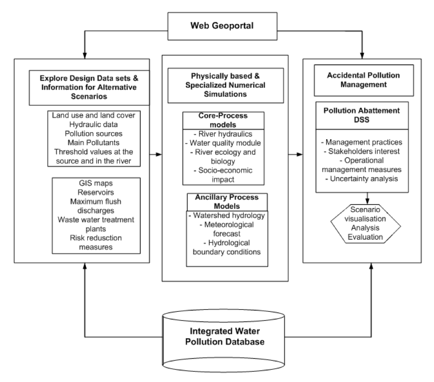
The decisional process is typically iterative, ideally with a progression between iterations. This is labeled by [GWP, 2009] as the spiral management model. For this purpose, a needed provision for the decision system is to allow changes that lead to improved decision-making in a continuous manner. This objective can be easily accomplished by using computer-based decision platforms that can efficiently assure the cyclical rebound in earlier stages of the decision process [Muste, 2013]. A simplified view of the activity phases embedded in a DSS block diagram is shown in Figure 13. After the identification of the processes that require short-term and long-term interventions, all the alternative remediation actions have to be analysed based on specific optimization criteria, and ranked according to a set of criteria. After implementing the immediate mitigation actions, evaluation of the result has to be critically assessed to infer the favorable/detrimental changes in the initial situation.
Figure 13. Specific elements of the customized DSS for accidental pollutant mitigation.
Case study: IoWaDSS Technological Framework
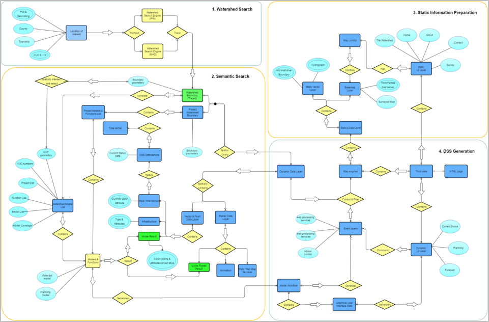
The skeleton of the IoWaDSS architecture is an ontological framework, which initially comprises hydrologic concepts and their relationships with elements of computer science and GIS. This ontology is needed, as the DSS has to handle information that is not in a structured form from computational perspectives. The ontological framework reduces the system complexity and maintenance, while increasing platform flexibility and interoperability. The creation of the ontological framework includes the identification and organization of the functional and domain requirements, and the user scenarios tailored to users’ needs and characteristics. For this purpose, background interviews and questionnaires on the local watershed community members have been conducted, assembled, and converted in information and workflow elements. The garnered information was embedded in the system components functionality and the flux of information between the workflows.
For the DSS domain purposes, the ontological framework is focused on watershed management; therefore a watershed-centered ontology is the basis of system architecture (Figure 14). The ontology associates natural resources (e.g. data, real-time models, simulation results) and user scenarios (e.g. planning process, management workflows) with the hydrologic units (e.g. watersheds, rivers, hydrologic regions) they pertain to. Depending on the watershed-based organization, resources and user scenarios can be integrated into the river connectivity network. Such structures enable users to access hydrologic resources in the context of watersheds and spatial location. The generic flux for the DSS contains:
- (i) a watershed search system to identify the upstream watersheds and their basin identifiers (e.g. GNIS ID, HUC numbers) based on the user’s Point Of Interest (POI),
- (ii) a semantic search system that queries specific decision-related resources, such as real-time sensors, modelling results, land-cover, and soil data within the traced upstream area from the watershed search engine,
- (iii) user interfaces for interacting with the system (e.g. basemaps, user interface) for specific decision support processes,
- (iv) DSS outcomes that contain the post-processed DSS information generated through the planning process. This information is associated with the decision support workflows (e.g. through the planning process and forecasts).
Figure 14. The IoWaDSS Ontological Framework.
The IoWaDSS platform is currently in development along with its beneficiaries: watershed management authorities [IDNR] that have been formed in many of the Iowa watersheds to take ownership of the water problems at the community level. DSS such as IoWaDSS provides numerous benefits to local and regional stakeholders by allowing users at multiple scales to engage in a meaningful dialogue across jurisdictions. The platform connects top-level agencies and expertise with community-level non-technical groups in their common effort to enhance and monitor the health of the watersheds. Regulators, planners and the communities explore collaboratively the impacts of land use and climate changes on watershed hydrologic response and evaluate the inherent social, environmental and economic trade-offs that occur. The centralized data repository and modelling platform developed through this study allows stakeholders from the Federal to the local level to rapidly compile the existing conditions, develop, compare and evaluate alternative scenarios within an integrated water resources management approach. Visualization of the scenario results web-based interactive maps and query interfaces for communication with stakeholders make the decision process sustainable and manageable. It can be concluded that the DSS can become a powerful tool for helping users across all levels and organizations by supporting their decision-making and communication efforts towards their common goals of sustainable and resilient watersheds.
Accidental water pollution
The occurence of an accidental water pollution can have dramatic consequences such as threatening the life of people that use the water for domestic purposes, or compromising dependent economic activities (e.g., agriculture, fishing).
The reduction of the concentration of pollutant on any river after an accidental pollution happens can be realized using dilution and introducing an additional amount of clean water released from the dams placed on the river’s tributaries.
Paper [Ciolofan, 2018] presents a solution to cope with water pollution. Firstly, a hydraulic simulation and the pollutant transport have been realized by using proffesional software packages (MIKE11) for two scenarios: no dilution and dilution (bottom gates of the dams open). A database was created, containing the results of simulations of pollutant transport for various values of the pollution parameters in both diluted/undiluted scenarios. Based on this data, a web decision support tool that presents a modern intuitive and easy to use GUI was implemented. The end-user are presented straightforward actions to be taken (e.g., "Open the bottom gates of the reservoir X at time T1 and close them at time T2). Additionaly, synchronized charts depicts the effects of the dilution in respect to the concentration of pollutant at certain locations along the river. The authors proposed an heuristic method for dilution and showed that using the proposed approach a reduction of pollutant concentration in the river with up to 90% can be obtained.